Beschrijving
Open User Map is a flexible map plugin for creating custom maps, community maps, directories, store locators and location-based projects.
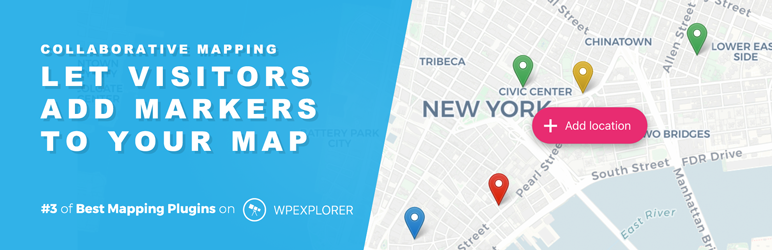
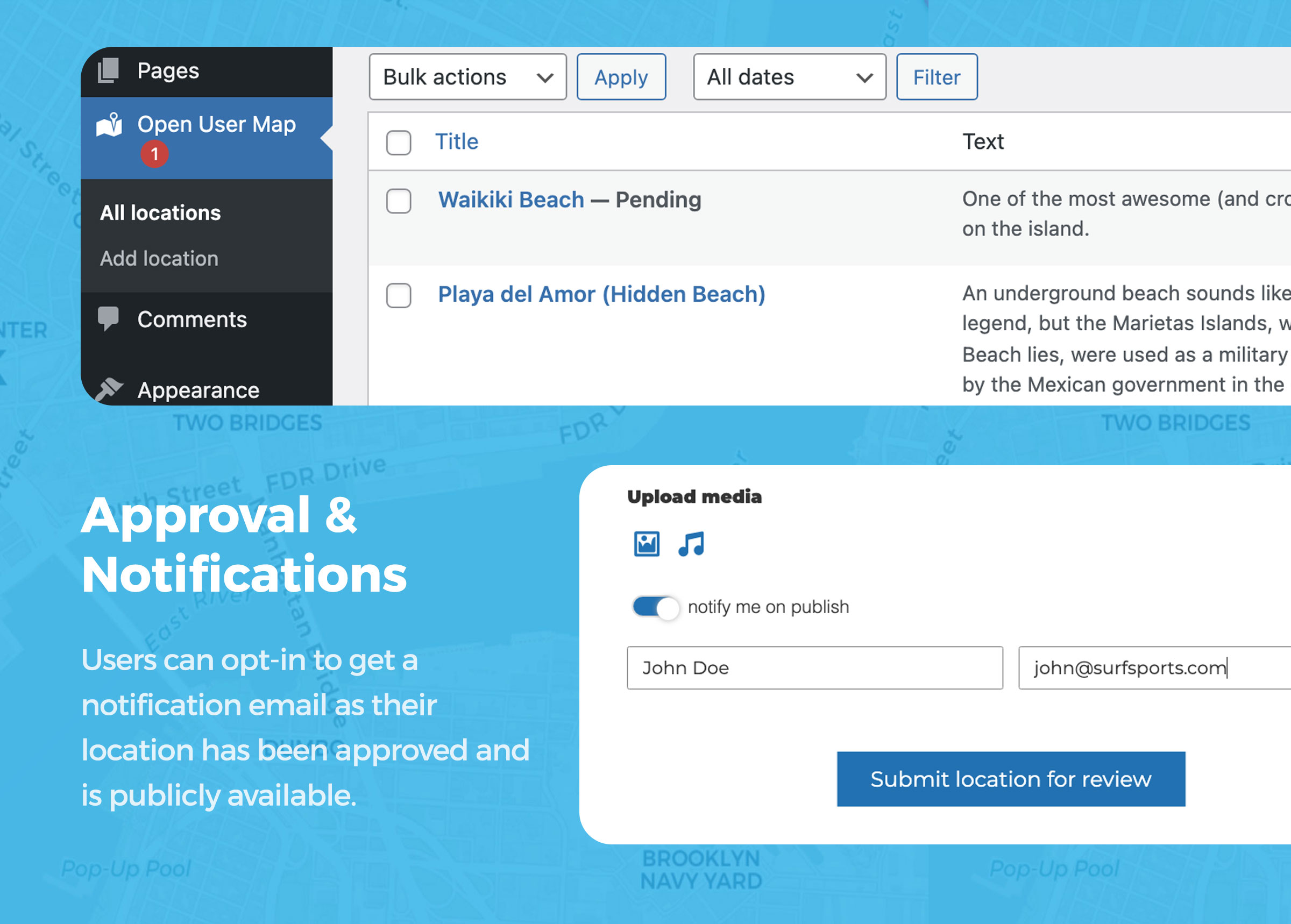
You can add your own markers — or let website visitors submit new markers directly from the frontend. New submissions can wait for your approval before they appear on the map, so you stay in full control.
No Google Maps API key is required. Open User Map is based on Leaflet Map JS and includes free OpenStreetMap and MapBox based map styles, marker styles, address search and flexible embed options for Gutenberg, Elementor and shortcodes.
Want to test all premium features? Start the 7-day Open User Map PRO Trial — no credit card required.
🚀 Start 7-day PRO Trial (No Credit Card) | 🔥 See Live Demos | 📖 More Info | ❓ Help
What can you build with Open User Map?
📍 A simple custom map – Show your own markers on a beautiful interactive map.
👥 A community map – Let visitors add new markers directly from the frontend.
✅ A moderated map – Review and approve new marker submissions before publishing.
📡 A store locator – Showcase business locations and help visitors find nearby places.
🔎 A filterable directory map – Organize markers with categories, search and custom fields.
😎 Personalized user maps – Show individual maps for signed-in users.
Why Choose Open User Map?
✅ Beautiful interactive maps – Create modern maps that do not feel like boring default map embeds.
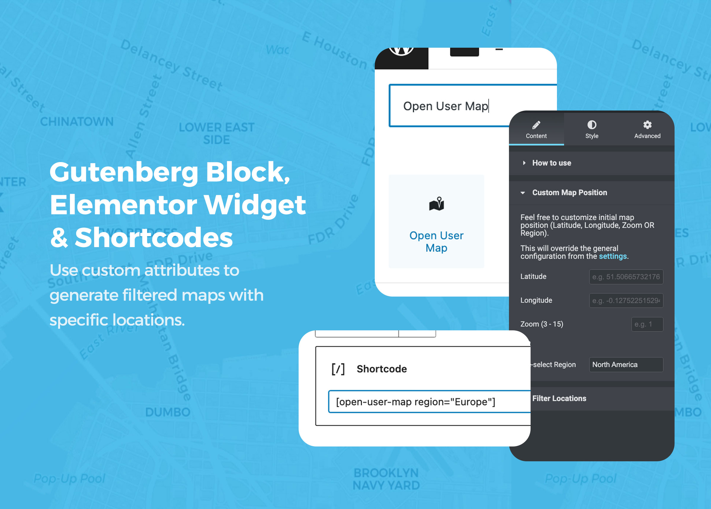
✅ Made for WordPress – Embed maps with Gutenberg blocks, Elementor widgets or shortcodes.
✅ Frontend marker submissions – Visitors can add pins without backend access.
✅ Approval workflow included – Keep control over what gets published.
✅ No Google Maps API key required – Avoid API setup, access tokens and Google Maps restrictions.
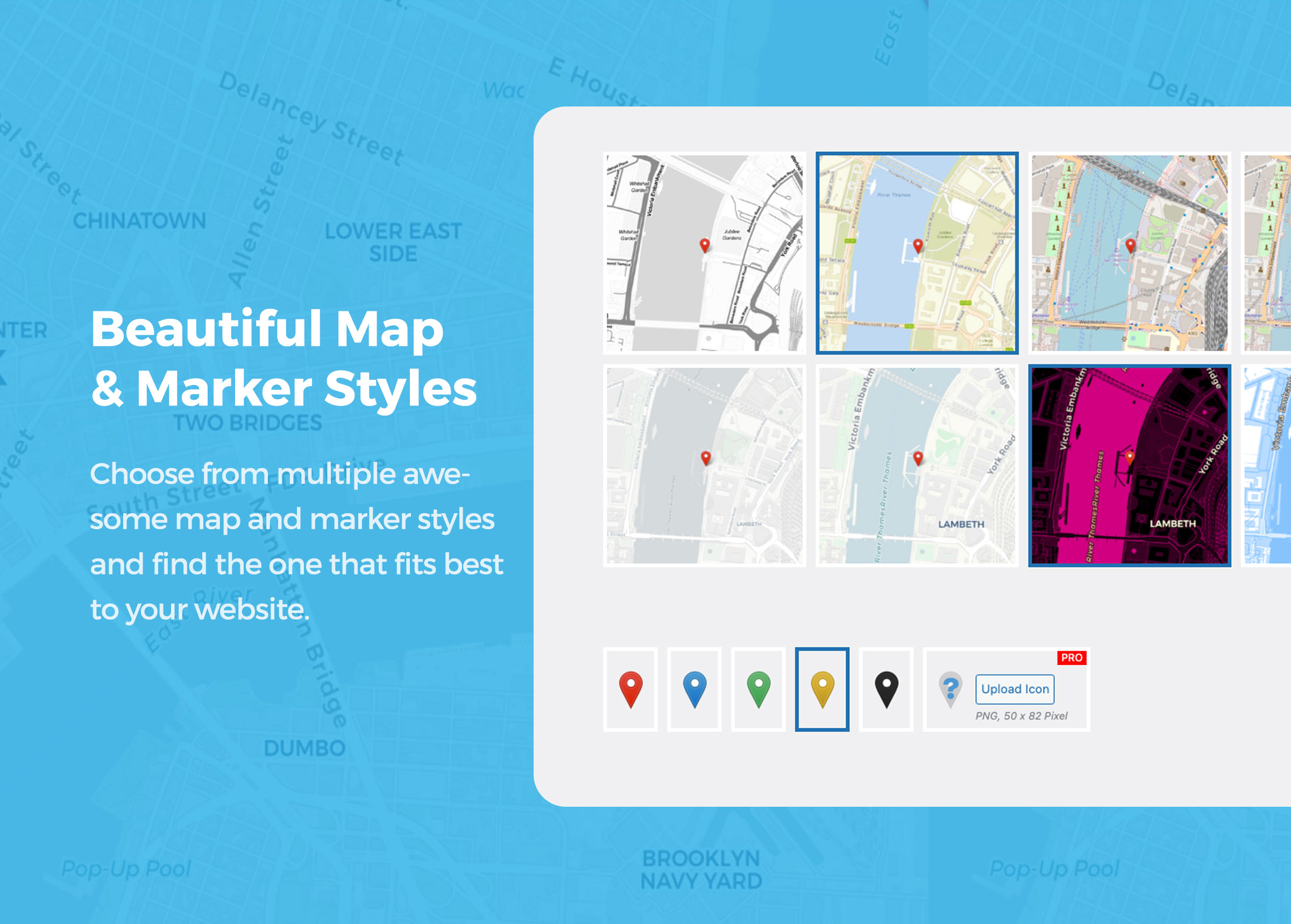
✅ Multiple map styles – Use OpenStreetMap, MapBox and other flexible map styles.
✅ Powerful search options – Marker search, address search and category filtering.
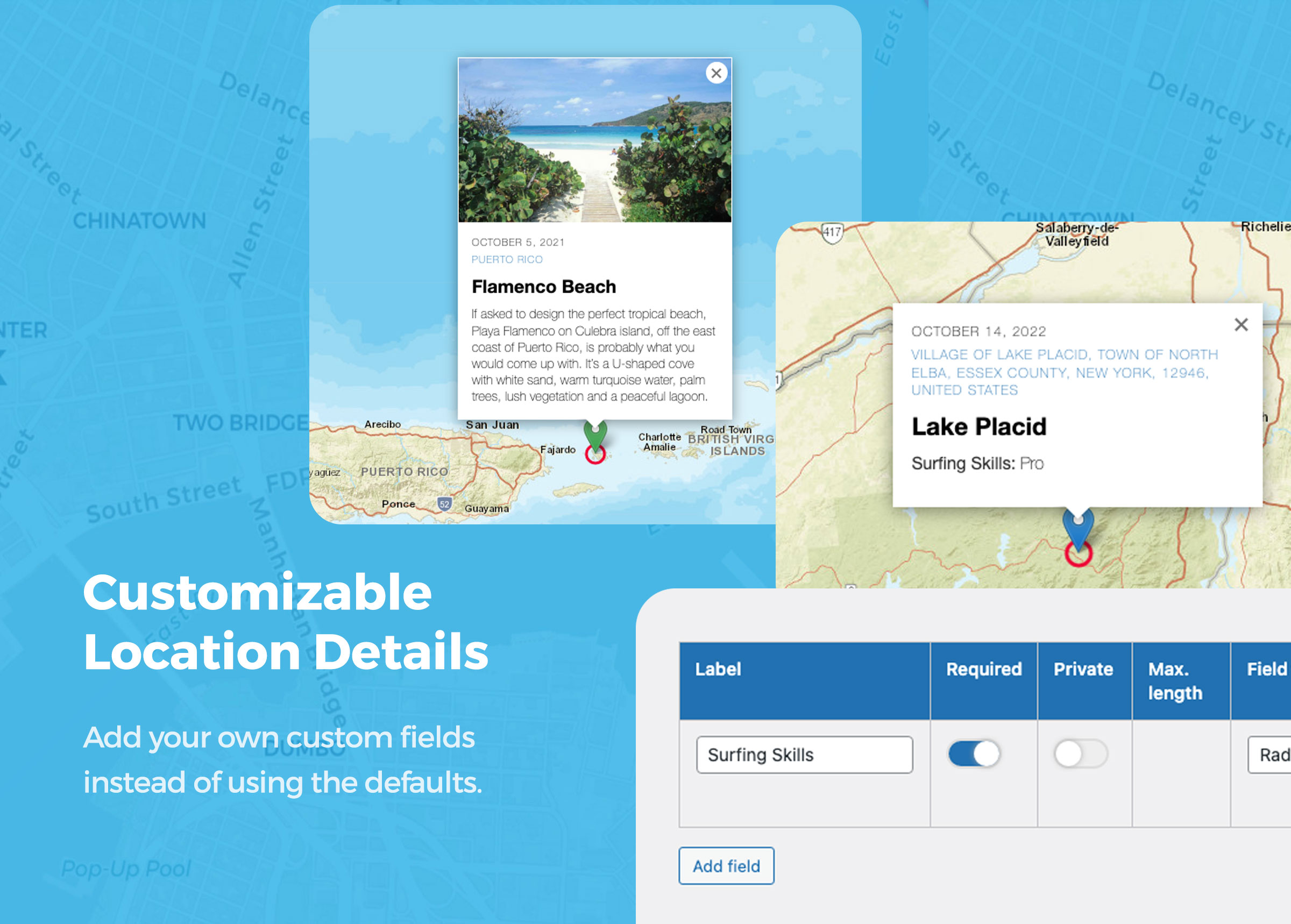
✅ Customizable forms & fields – Collect the exact location data you need.
✅ Media-rich markers – Add descriptions, images, audio, videos and more.
✅ Perfect for directories, community maps, travel blogs, events, local guides and business locations.
Get a Map in 1 Minute
🍿 Watch Video on YouTube: Getting Started with Open User Map
🌏 How to create a Simple Map
Create a clean, customized map that shows only your own markers. This is perfect for business locations, travel spots, event places, real estate listings or any other collection of places you want to display on your website.
You can disable visitor submissions and use Open User Map as a simple custom map plugin for WordPress.
🍿 Watch Video on YouTube: How to create a Simple Map
👩🏾🚀🤵👩🏻🎤👩🏽🌾👩🏿💻 How to create an Interactive Map
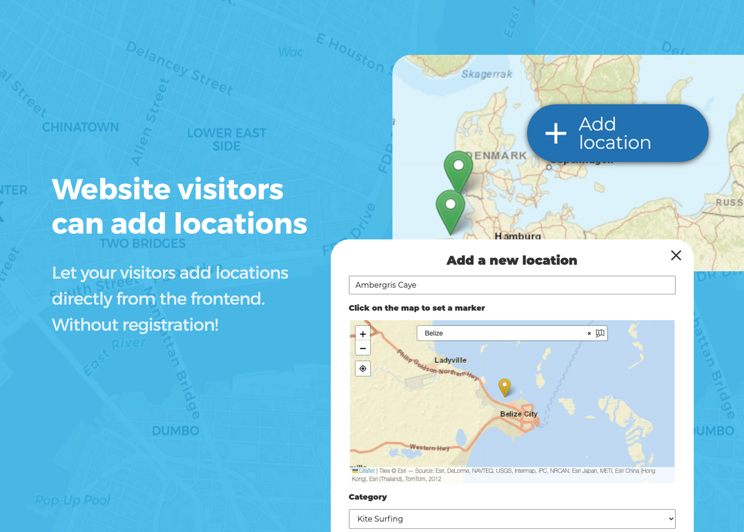
Create a community map where visitors can add new markers directly from the frontend. You can receive a notification for new submissions and approve each location before it is published.
Your visitors can search for addresses or existing markers worldwide to quickly find the right spot. You can add custom fields and descriptions to the submission form to collect the data you need. Image, video and audio uploads are possible as well.
Let your users collaborate and watch your map grow.
How your website visitors add new markers to your map:
Visitors simply click the “+” button on the map. A form opens where they can enter the location details in a comfortable frontend interface. After submitting, the new marker can be saved as “pending” and wait for your review before it gets published.
🍿 Watch Video on YouTube: Add a new Location
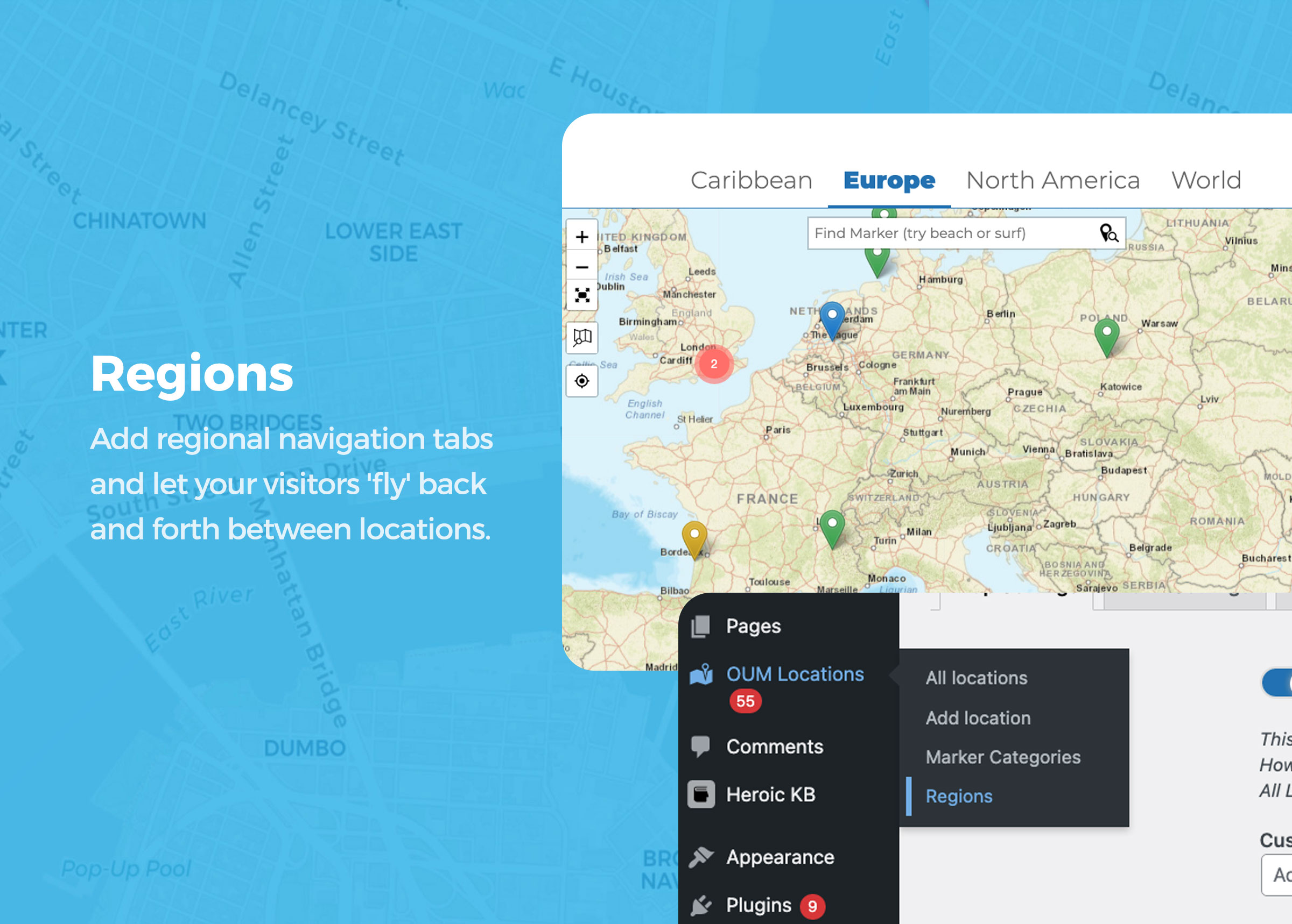
🆕 Regions
Add regional navigation tabs and let your visitors fly back and forth between locations that are far apart from each other. This is useful for maps covering multiple cities, countries, regions or large areas.
See the Demo Map.
🍿 Watch Video on YouTube: Regions
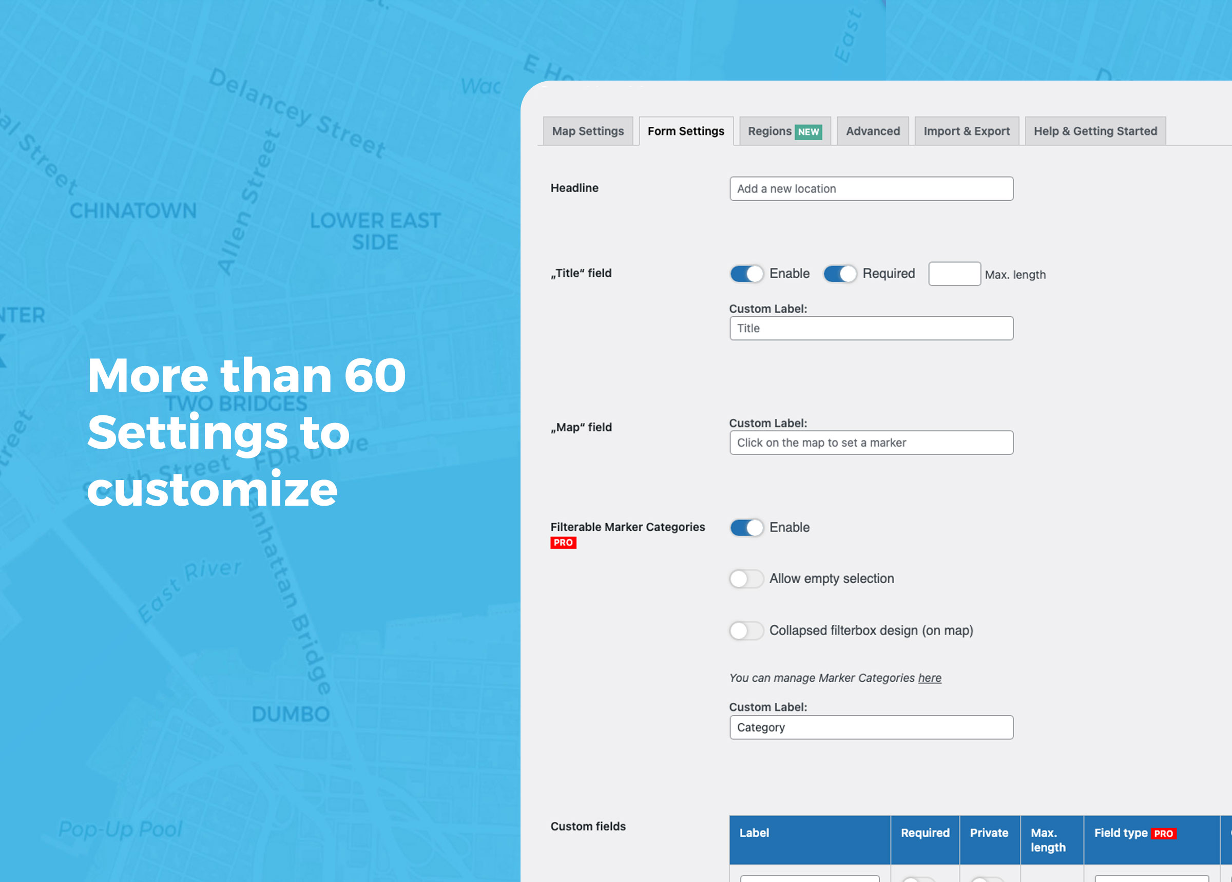
More than 60 options to customize
Use the Gutenberg Block, Elementor Widget or shortcode to add your map anywhere on your WordPress site.
Nearby markers can be grouped together with marker clustering. You can customize the map size, marker styles, map focus, search options, frontend form fields, text labels, redirects, thank-you messages and much more.
Custom fields allow you to adapt the marker submission form to your exact use case.
Free Features:
- frontend adding of markers (can be disabled)
- frontend editing of locations for registered users
- admin approval for pending locations
- based on Leaflet
- no API keys required
- multiple map styles including MapBox
- GDPR-ready map tiles with servers in Germany
- multiple marker styles
- Regions as tabs 🆕
- full-width map size
- keep map focus in fixed position (stay in an area)
- optional scroll wheel zoom 🆕
- search for markers 🆕
- address search with OSM geosearch
- auto-generate address from marker location with reverse geocoding 🆕
- locations with custom fields 🥳
- private custom fields
- pre-filter locations by custom fields
- pre-filter locations by date or date range
- conditional fields (🪄 experimental, please see Help section)
- “subtitle”, “description”, “image”, “audio” and even “title” fields can be disabled
- “subtitle” field links to Google route
- every text bit can be customized
- locations with images and audio
- multiple images as slider per location 🆕
- shortcode with custom settings
- Gutenberg Block with custom settings
- Elementor Widget with custom settings
- marker clustering
- fullscreen option
- refresh, redirect or thank-you message after submit
- use URL parameter &markerid=123 to highlight a specific marker on the map
- get a specific value from a location by using the PHP function oum_get_location_value( ‘YOUR VALUE’, $post_id )
- use WordPress hooks to extend the plugin functionality with your own code, including a hook to modify location data before rendering 🆕
- use shortcode [open-user-map-form] to display the “Add Location” form stand-alone
- custom JS inputs
- custom CSS inputs
🚀 PRO
Open User Map PRO gives you more control, more automation and more flexibility for advanced community maps, directories and professional map projects.
You can try all PRO features for 7 days — no credit card required.
🔥 Start 7-day PRO Trial (No Credit Card)
⭐️ Filterable Marker Categories
Organize locations in multiple filterable marker groups. Each group category can have an individual marker icon and will be accessible to visitors.
⭐️ Lines & Areas
Add Lines and Areas as additional location types. Visitors can draw routes, paths, zones or boundaries directly on the map.
⭐️ Live Marker Filter
Use the search bar to filter markers as you type. Instantly see relevant locations on the map.
⭐️ Advanced Filter Interface
Create a filter sidebar next to your map and let visitors filter locations by any custom field you have configured. You can also add custom HTML content sections to display additional information or branding.
⭐️ Custom Image Map Style
Add a custom image layer to your map or replace the map entirely with a custom image, such as a floor plan, event map, seating plan or fantasy map, while keeping interactions, clustering and popups.
⭐️ Pre-filter locations by user or role
Use shortcode attributes to filter locations by current user, user ID or role. This works for maps, lists and galleries.
⭐️ Vote button for locations
Add a customizable button for likes, upvotes or flagging, with flexible privacy controls.
⭐️ Star Rating
Let visitors rate locations with a customizable star rating system.
⭐️ More custom field types
Add custom fields such as links, radio buttons, checkboxes, dropdowns, opening hours and HTML. Social media links can automatically be rendered as icons.
⭐️ Additional geosearch providers
Use additional geosearch providers including Geoapify, HERE and MapBox.
⭐️ Videos from YouTube & Vimeo
Use videos instead of images to highlight each location.
⭐️ Export & Import locations
Already have a list of places you want to show on the map? Use CSV export and import to add, move or bulk edit locations more easily.
⭐️ Email user notification
Notify users by email after their location has been approved.
⭐️ Email admin notification
Send notifications to an admin email address when new location proposals are submitted.
⭐️ Zapier/Webhook Integration
Trigger an external webhook when locations are created or updated.
⭐️ User restriction
Restrict the “Add location” feature to registered users only and redirect visitors to your registration form.
⭐️ Auto-publish
Let registered users publish directly without admin approval. This can also be enabled for unregistered users.
⭐️ Extend user registration
Add the “Add location” feature to the WordPress user registration form.
⭐️ Custom filesizes
Customize the maximum filesize for image and audio uploads. The default is 10 MB.
⭐️ Custom marker icons
Use your own custom marker icons.
⭐️ Current location
Add a button that moves the map to the visitor’s current location.
⭐️ Limit visible locations
Limit the locations shown on a map by marker categories or post IDs. This makes it possible to show only locations of a specific type or render a single location. This can be done in the block settings or with shortcode attributes.
⭐️ Single pages for locations
By default, locations do not have single pages. This helps prevent large numbers of location posts from negatively affecting your SEO. If you want to add more content to locations, you can enable single pages in Open User Map PRO.
⭐️ Default template for single pages
When single pages are enabled, locations automatically get a post thumbnail, an excerpt and a default content template. You can also show locations within query loop blocks to create your own list or grid view.
⭐️ Shortcodes for single location values
Use the shortcode [open-user-map-location value=”YOUR VALUE” post_id=”POST ID (optional)”] to display a value from a location. This is useful when creating single pages for locations. You can find all available values in the Help section of the plugin settings under Open User Map > Settings > Help.
⭐️ Show all location images as gallery
Use the shortcode [open-user-map-gallery] to display a gallery view of all location images. Each image links to the corresponding location marker on the map.
⭐️ Show all locations as list or grid
Use the shortcode [open-user-map-list] to display all locations as a list. Alternatively, you can use native query loop blocks to build a custom list or grid.
⭐️ Allow registered users to edit their locations
Open User Map PRO extends WordPress capabilities to allow backend access. If assigned to the user role, registered users can read, edit and delete their own locations from within the map.
🔥 Start 7-day PRO Trial (No Credit Card)
Use Cases
🍕 Restaurant & Food Guides
Build a collaborative map where visitors can add locations on their own. This is great for travel blogs, city guides, bar maps, restaurant guides or local recommendation platforms.
Ask your audience for their favorite food and drink spots. Prepare categories such as food, drinks, music or nightlife and let visitors drop markers directly from the frontend. Watch your map grow fast.
👭👬 Community Building
Extend the WordPress user registration form with an “Add location” input. New users can drop a marker on the map to share their location.
Use it to build a user map and help your audience connect with each other.
📺 Video Tour Map
Bring locations to life with video. Let visitors enhance markers by embedding YouTube or Vimeo videos directly on the map.
This could be a video tour of a neighborhood, a restaurant walkthrough, a city guide or a cultural event highlight. Perfect for travel bloggers, city guides and virtual tours.
🎤🎸 Sound Map
Create a sound map and let your audience upload audio files to locations.
This is useful for documenting soundscapes in urban or remote areas, collecting field recordings, building audio tours or creating creative map-based projects.
🎯 Business Directory
List businesses on a map with categories, filters, search and custom fields.
🗺️ Event or Travel Maps
Show tour locations, landmarks, event places, routes or recommended spots.
🏠 Real Estate Listings
Display properties with images, videos, descriptions and custom details.
📍 Store Locator
Make it easy for customers to find physical store locations.
📖 View More Examples & Live Demos
The possibilities are endless. We are very curious about what you are building with the help of Open User Map. Please do not hesitate to contact us, share your project or ask for feature requests. This plugin is under constant development and your feedback helps us improve it.
Schermafbeeldingen
Blokken
Deze plugin heeft 1 blok.
- Open User Map Insert a custom map featuring your own locations or an interactive map where anyone can add location pins without registering.
Installatie
From your WordPress dashboard
- Visit Plugins > Add New
- Search for “Open User Map”
- Install and activate Open User Map from your Plugins page
- Use the default WordPress editor or Elementor to insert the “Open User Map” block onto a page. Alternatively, you can use the shortcode
[open-user-map]. - You can manage locations in the “Open User Map” menu.
- You can manage styles and features under “Open User Map > Settings”.
FAQ
-
Do I need Google Maps or a Google Maps API key?
-
No. Open User Map is a WordPress map plugin based on Leaflet, OpenStreetMap and MapBox based map styles. You can create custom interactive maps without setting up a Google Maps API key.
-
Can I create a custom map with Leaflet, OpenStreetMap or MapBox styles?
-
Yes. Open User Map includes free Leaflet-based map styles and supports OpenStreetMap and MapBox based styles. You can use it as a simple custom map plugin or as an interactive community map.
-
Can visitors submit markers from the frontend?
-
Yes. Website visitors can add new markers or location submissions directly from the frontend. You can enable or disable frontend marker submissions in the settings.
-
Can I approve marker submissions before they appear on the map?
-
Yes. New frontend location submissions can wait for your approval before they are published. This makes Open User Map useful for moderated community maps, directories and collaborative projects.
-
Can I create a simple custom map without visitor submissions?
-
Yes. You can disable frontend submissions and use Open User Map as a simple custom map to show your own markers, business locations, travel spots, event places or other locations.
-
Can I add marker search, address search and filters to my map?
-
Yes. Open User Map supports marker search, address search and filter options. You can help visitors find locations on the map and organize markers with categories and custom fields.
-
Can I use marker categories or filter markers by category?
-
Yes. Marker categories can be used to group, style and filter locations. In Open User Map PRO, marker categories can also have custom icons and advanced filtering options.
-
Can I embed the map with Gutenberg, Elementor or a shortcode?
-
Yes. Use the WordPress Block Editor, Elementor Widget or the shortcode
[open-user-map]to embed your map. You can also use the shortcode in a theme template with PHP:echo do_shortcode("[open-user-map]") -
Can I create a store locator, business directory or community map?
-
Yes. Open User Map can be used for store locators, business directories, community maps, travel maps, event maps, real estate maps and other location-based projects.
-
Can I import or export map locations?
-
Yes. Open User Map PRO includes CSV import and export for locations. This is useful if you already have a list of places, want to bulk edit markers or need to migrate location data.
-
Can I show only specific markers, categories or locations?
-
Yes. You can limit visible locations by marker categories, post IDs and shortcode attributes. This is useful for showing different maps, directory sections or location groups on different pages.
-
Can users upload images, audio or videos to markers?
-
Yes. Locations can include descriptions, images and audio. Open User Map PRO also supports videos from YouTube and Vimeo, plus additional media and field options.
-
Can registered users edit or delete their own locations?
-
Yes. Open User Map supports frontend editing for registered users. Depending on your settings and capabilities, users can edit or delete their own submitted locations.
-
Can I show the visitor’s current location on the map?
-
Yes. You can enable a current location button so visitors can move the map to their own position. This is useful for local maps, nearby places, directories and store locator use cases.
-
Can I customize marker icons, colors and map styles?
-
Yes. Open User Map includes multiple marker styles, map styles and UI color options. Open User Map PRO adds custom marker icons and additional styling options.
-
Can I use custom fields and developer hooks?
-
Yes. You can add custom fields to collect the exact location data you need. Developers can also use WordPress hooks, custom CSS and custom JavaScript to adapt the map output.
-
Where do I find help or report security bugs?
-
Please check our Knowledge Base and search the Support Forum. Security bugs can be reported through the Patchstack Vulnerability Disclosure Program.
Beoordelingen
Bijdragers & ontwikkelaars
“Open User Map – Interactive Leaflet Maps” is open source software. De volgende personen hebben bijgedragen aan deze plugin.
Bijdragers“Open User Map – Interactive Leaflet Maps” is vertaald in 3 localen. Dank voor de vertalers voor hun bijdragen.
Vertaal “Open User Map – Interactive Leaflet Maps” in je eigen taal.
Interesse in ontwikkeling?
Bekijk de code, haal de SVN repository op, of abonneer je op het ontwikkellog via RSS.
Changelog
1.4.43
- Added FR and ES translations
1.4.42
- NEW: Lines & Areas as additional location types
- Improved: Shortcode attribute for list pagination
- Improved: Load dashicons.css when needed only
- Improved: RTL support
- Bugfix: Image Upload fails if filesize is too big
- Bugfix: Inactive “Add Location” form
1.4.41
- Bugfix: Caching issues with loading location data
1.4.40
- Bugfix: Votes/Rating got reset when updating location in the backend
- Bugfix: Image Slider in Location popup was missing
1.4.39
- Bugfix: Missing markers when Marker Clustering was enabled
- Bugfix: Private custom fields appear empty on Edit
- Improved: Location Submissions Settings
1.4.38
- Improved: Better performance through lazy loading for location popups
1.4.37
- Improved: Font size in geosearch results
- Improved: Better performance through lazy loading for location popups
- Freemius SDK update
1.4.36
- Bugfix: Faster Batch Loading failed for single markers
1.4.35
- Improved: Increased Cluster Radius
- Improved: Coordinates Sanitization (Import)
- Improved: Faster Batch Loading for Markers
1.4.34
- NEW: Setting to disable marker popups
- Improved: Compatibility with lazyloads
1.4.33
- Improved: Compatibility with lazyloads
1.4.32
- Bugfix: Allow Location post type to be accessible to Elementor
- Improved: Security
1.4.31
- Improved: Auto-publish workflow is now consistent – admins always auto-publish, other roles depend on “Registered users can add locations without approval” (default: off)
- Improved: Flush rewrite rules when toggling single-page mode so location permalinks update immediately
- Improved: Store individual zoom levels with locations
- Improved: Fast zoom for maps in settings
- Improved: Wizard & Settings UI
1.4.30
- NEW: Sort lists by title, date or custom fields (shortcode attribute)
- Improved: Handling of output buffer enhancements (automatic opt out for OUM outputs)
- Improved: CSV exports in chunks now allows very large datasets to be processed
- Improved: Compatibility with Complianz plugin
- Improved: Location search in the dashboard
- Bugfix: Prevent JS crash when fullscreen popup container is missing
- Bugfix: Prevent JS crash when map element is missing during loader initialization
- Bugfix: Prevent fatal error when mbstring extension is unavailable
- Bugfix: Prevent vote AJAX warnings on malformed requests
- Bugfix: Prevent opening-hours parser crash on unexpected field names
- Bugfix: Handle unavailable WordPress upload directories in upload flows
- Bugfix: Add defensive DOM guards for frontend form and backend settings interactions
- Bugfix: Prevent CSV import crashes when file handles cannot be opened
- Bugfix: Harden CSV import against malformed and empty rows
1.4.29
- Temporary Fix: Manual opt in for handling output buffering layers
1.4.28
- Revert changes related to handling output buffering layers (1.4.25 and 1.4.26)
1.4.27
- Bugfix: Site layout crashed after updating to version 1.4.26
1.4.26
- Bugfix: Site crash on plugin activation when Freemius initialization fails (e.g., expired licenses, recovery mode)
- Improved: Compatibility with themes that add output buffering layers
1.4.25
- Improved: Allow rewrite slug to be customized (buggy in 1.4.24)
1.4.24
- Bugfix: Plugin crashes on activation (in rare circumstances)
- Improved: Debug Info (Settings > Help & Getting Started > Debug Info)
1.4.23
- NEW: Custom Field Type “Opening Hours”
- NEW: Star Rating
- NEW: Auto-generate address from marker location (Reverse Geocoding)
- NEW: Hook to modify location data before rendering
- Bugfix: Admin notification on new location proposals
- Bugfix: Elementor breaks video player
- Bugfix: Breaking issues with Elementor’s Element Cache
- Improved: Post Type Location is now available to Elementor by default
- Improved: Elementor editor block style
- Improved: “Edit” button is now cache independent
1.4.22
- NEW: Visual Editor to position custom overlay image on the map
- Improved: Keep map focus in fixed position
- Bugfix: Ensure Custom JS is loaded in all environments
1.4.21
- Improved: Location popup style
- Improved: Aspect ratio of form map
- Bugfix: Admin notifcation on auto draft
- Bugfix: Placeholder for query filters in Bricks Builder
1.4.20
- Improved: New CSV import setting: Publish imported locations immediately
- Improved: Stay on the active settings tab when saving
- Improved: Update notice
- Improved: Display current version in the settings
- Improved: Getting Started notice
- Bugfix: Mark custom field label as “required”
1.4.19
- Improved: Form styles
- Improved: Replaced composer auto-load with custom solution
- Improved: Allowing to set AND/OR relation for checkbox filter (Advanced Filter Interface)
- Bugfix: Custom CSS did not load
1.4.18
- Bugfix: CSS did not load in rare cases
1.4.17
- Improved: Webhook Data
- Improved: Initial Map Position
- Improved: Font styles
- Security Fix
1.4.16
- NEW: New map style: Custom Image [PRO]
- NEW: Advanced Filter Interface [PRO]
- NEW: New shortcode attribute to filter by Custom Fields
- NEW: New shortcode attribute to filter by date
- NEW: Advanced Settings > Custom CSS field
- Improved: Adding data-custom-field-label to custom field wrapper for better css customization
- Improved: Auto-publish for registered users by default
- Improved: Allow multiple selections in custom field of type “select”
- Improved: oumConditionalField() function
- Improved: Add visible labels to all form fields
- Improved: Map Settings: smaller zoom steps
- Improved: Allow JSON return for [open-user-map-location] shortcode
- Improved: Better UX for code snippets (Help Section)
- Improved: Added JS API Documentation to Help & Getting Started
- Improved: Freemius SDK update
- Bugfix: Compatibility with Borlabs Cookie Content Blocker
- Bugfix: Renaming “address” field to “subtitle” (CSV & Docs)
- Bugfix: Custom map style on location map value
- Bugfix: Sanitization on link fields
- Bugfix: Incorrect Nonce
- Bugfix: Elementor Widget Flexbox issue (no width set by default)
- WordPress 6.9 compatibility
1.4.15
- Security Fix
1.4.14
- style improvments
1.4.13
- New: Use Shortcode [open-user-map-form] to display the “Add Location” form stand-alone without showing the map
- New: Showing category icons in the form
- New: Showing category icons next to location title (optional)
- New: Customize the “Close and refresh map” button text
- Fix: PHP Notice
- Freemius SDK update
1.4.12
- New: “Select all” toggle for categories
- Fix: Required option for custom field type Select is broken
- Fix: Required image upload field is invalid on Edit although image already exists
- Fix: < Symbol gets removed from the custom text field
- Fix: oum_get_vote_count (admin_ajax) takes too much loading time (list view)
- Fix: YouTube URLs are missing in the CSV export
- Fix: Carousel navigation areas
- Fix: server error when error_log function has been disabled
- Fix: vote count resets on edit
- New: Hook to customize the default single location content template
- Security improvements
1.4.11
- Bugfix: Default Marker Icon setting was ignored
- New PRO Feature: Vote Button (Like, Upvote, Flag, …) for Locations
1.4.10
- New: Shortcode option types-relation=”AND” to show only locations that match all selected categories
- New: Special icon for locations with multiple categories (can be customized)
- Fix: Featured images were duplicated instead of reused when selecting an existing image
1.4.9
- Clean UTF-8 encoding for location data (Repairs data if needed)
- Update Help Section: Use oum_get_location_value(‘images’) instead of oum_get_location_value(‘image’)
- Advertise Trial in the Settings (New Tab “Start Free Trial”)
- Load Textdomain earlier (init with Prio 1)
- Freemius SDK update
1.4.8
- 🚀 Performance Boost: Preload media library attachment IDs
1.4.7
- Attaching German translations to the PRO version
- Bugfix: Prevent JS error on failed map initialization
- Bugfix: CSV import for multisite setups
- Backend style fixes
- Freemius SDK update
1.4.6
- New Setting: Number of possible image uploads (1-5)
- Assign the current user to locations that are not assigned already (on approval)
- Style Fix: Read More
- Bugfix: PHP Notice (_load_textdomain_just_in_time)
- Bugfix: PHP Warning on empty locations array
1.4.5
- WordPress 6.8 compatibility
- Set Individual Map Zoom for each Location
- UI Elements color setting is now available in free version
- Add “post_id” to webhook payload
- New option: Image Size in Popup (Original or Cover with Aspect Ratio)
- Bugfix: Marker Search auto suggest
- Bugfix: Use assigned Marker Category Icon for [open-user-map-location value=”map”]
- Bugfix: Current Location
1.4.4
- Restrict “Delete Location” button by “delete_oum-locations” capability
- Bugfix: Doubled site path in image urls (only on Multisite with folder)
- Bugfix: Youtube Video continues playing after closing the location (on mobile)
- Bugfix: Edit icon not clickable on iPhone
1.4.3
- Bugfix: Automatic creation of featured image and excerpt
- Remove _blank target from custom field link
- Storing images always as relative paths
- Make sure site_urls with folder do work with relative images
- PRO: Shortcode Attribute to filter locations by current user, user_id or a role
1.4.2
- Bugfix: “Add Location” without image upload field failed
- Bugfix: “Upload Media” label was missing
- Bugfix: “use label as link text” did not work in list view
- Prevent inline JS from being processed by Caching and Pagespeed plugins
1.4.1
- Bugfix: Filter by Post IDs
- Bugfix: Custom Field order not correct (Frontend)
- Bugfix: No error message when adding images that are too large
- Feature Request: %user_email% and %user_name% in admin notification email
- Freemius SDK update
1.4.0
- Feature Request: Multiple images (carousel) per location 🥳🥳🥳
- Complete JS restructure for better performance and scalability
- Performance Boost: Reduce number of db queries by 80%
- Performance Boost: Better handling large number of custom fields
- New Image Gallery Style
- Optimized Settings UI
- Optimized Single Location Template
- Added ID column to OUM Locations table
- ARIA-labels optimization
- Freemius SDK update
1.3.54
- Add “Edit Location” capability for “subscriber” role
- Bugfix: Compatibility issues when using shortcode with some page builders
- Feature Request: New Date Settings to show last modified date OR published date
1.3.53
- Bugfix: Gutenberg Block Buttons
- Bugfix: Removing “Mobile Map Ratio” due to incompatibility with Elementors new “container” element
1.3.52
- Preserving the global Leaflet instance to prevent conflicts with other plugins
1.3.51
- Bugfix: List View style
- Bugfix: Marker Search input style
- Bugfix: Video style
- Feature Request: Trigger Webhook on new or updated Locations
1.3.50
- This release prioritzes feature requests regarding the flood disaster in Spain
- 🎉 Feature Request: Searchbar to Live Filter Markers (PRO)
- Feature Request: Allow template overrides
- Bugfix: Editing a location loses the image/audio
- Bugfix: Edit location button conditions
- Improving oumConditionalField feature to accept multiple event listeners
1.3.49
- This release prioritzes feature requests regarding the flood disaster in Spain
- Feature Request: Users can delete their own locations
- Feature Request: Backend search for locations now searches all fields
- Feature Request: show modified date instead of creation date
- Edit Form: “Add a new location” –> “Edit Location”
1.3.48
- This release prioritzes feature requests regarding the flood disaster in Spain
- Feature Request: New Icons (Attention, In Progress, Done, House, Person)
- Feature Request: Add YouTube & Vimeo videos to a location (PRO Feature)
- Close-Button for Filterbox
- Better responsive styles for Filterbox
- Ensure WordPress 6.7 compatibility
1.3.47
- Freemius SDK update
1.3.46
- Bugfix: Multilingual locations are not filtered by language
- Bugfix: Frontend adding
- Style optimizations
- Add location slug to searchable content (solves oe / ö search requests)
- Freemius SDK update
1.3.45
- Bugfix: “Locate” button failed
- Bugfix: Form Map position is initialy slightly off
- Bugfix: Mapbox address search failed sometimes
- Bugfix: Custom JS not loaded on Simple Map
- Bugfix: Using Mapbox/Here in registration form
- Bugfix: Mandatory image field in Frontend Editing
- Bugfix: Edit icon not clickable on iPhone
- 🎉 Feature Request: Registration: Set post author in favor of “User ID” field (now removed)
- Feature Request: wp_author_id field in export/import
1.3.44
- 🎉 Feature Request: Frontend Editing! Logged in users can now edit their locations directly within the map.
- Better Full Screen option (now available also on iOS)
- Data attributes to custom fields (list view)
- Use label instead of value for custom field “Link” (optional)
- Bugfix: Initial minimum zoom
- Freemius SDK Update
1.3.43
- Bugfix: Import breaks on empty line
- Bugfix: font colors on dark theme
- Add data attributes to custom fields
- Freemius SDK Update
- Ensure WordPress 6.6 compatibility
- Make locations translatable
1.3.42
- Bugfix: Filterbox not visible
1.3.41
- Bugfix: Collapsed filterbox on mobile
- Bugfix: Linebreaks in list view
- Bugfix: Marker Categories dropdown doesn’t show up
- Optimizing Settings page
1.3.40
- Bugfix: Marker Category Icons
- Improve Marker Category Box styling
1.3.39
- 🎉 Feature Request: Marker Categories can now be multi-select (adjust in the settings)
- Dynamic Marker Icon size
- Marker Icon mouseover animation
- Adding map tile provider attribution
- Freemius SDK update
1.3.38
- Bugfix: much better json encodes (should prevent code breaks)
- Bugfix: Prevent failing shortcode/block rendering by Slim SEO plugin
- Style fixes
- plugin version fix
1.3.36
- Bugfix: List View: Allow more than two locations
- Bugfix: jQuery error on single location pages
- 🎉 Default Single Location Template if no content or custom template is set
- 🎉 Better popup placement
- Set location image as featured image initially (on admin approval)
- Set location description as excerpt initially (on admin approval)
1.3.35
- Remove “made with OUM” notion
- Fixing incompatibility (image upload) with “Featured Image from URL (FIFU)” plugin
- UI Improvements
1.3.34
- Bugfix: Single map missing API key when using Mapbox
- Feature Request: Get Google route link with shortcode [open-user-map-location value=”route” post_id=”12345″]
- Feature Request: Shortcode to get all locations as list view
- Feature Request: Hook to customize output of the locations list item
- Reduced images file sizes (-75%)
- Freemius SDK Update
1.3.33
- Bugfix: CSV import validation
- Freemius SDK Update
1.3.32
- Bugfix: white text on white background
- ensure MapBox API key input
- Gutenberg Block: better UI
- temporary disable Freemius Garbage Collector [Beta]
1.3.31
- Freemius SDK update (incl. Garbage Collector [Beta])
- Block: move custom settings to Settings sidebar
- re-enable OUM attribution
- set WordPress downward compatibility to 5.5
1.3.30
- Bugfix: Trial workflow
- disable OUM attribution
- ensure WordPress 6.4 compatibility
1.3.29
- Ensure backend block styles are always correct
- Bugfix: Trial workflow
1.3.28
- Bugfix: php warnings
- Bugfix: oumMap and oumMap2 not available inside additional JS
1.3.27
- Make the map in the form accessable to JS customizations (oumMap2)
- Security improvement
1.3.26
- Bugfix: Trial workflow
- Removing Stadia Map Style (automatic switch to CartoDB Positron)
- New commercial map styles (MapBox)
- “MapBox” as geosearch provider option
- Fixing style issues
1.3.25
- Feature Request: extending the max world bounds a little bit (cheers to NZ!)
- Feature Request: New Map Style: Satellite
- Bugfix: compatibility issue with MapPress’s leaflet library
- Bugfix: compatibility issue with Complianz plugin
- Bugfix: compatibility issue with All In One SEO “Run Shortcodes” feature
- Bugfix: start longitute 0
- textarea font reset
- renaming “address” field to “Subtitle”
- renaming “notify on publish” to “Notify me when it is published”
- renaming “Enter address” to “Search for address”
- wording & language updates
1.3.24
- Major Bugfix: wrong JS dependency management
- leaflet providers library update
- updating map style (Stamen > Stadia)
- new custom field type “email”
- custom fields: open links in new tab
- better checkbox & radio button styles
- translations .pot file update
- Freemius SDK update
1.3.23
- Bugfix: wizard style
1.3.22
- rename “OUM Locations” menu item to “Open User Map”
- move “Settings” to “Open User Map > Settings”
- Wording
- prevent moving/zoom outside main world bounds
- Bugfix: Bubble images don’t cover (grey borders)
- Bugfix: Touchpad zoom too slow
1.3.21
- Bugfix: Map inside form uses custom icon
- Geoapify & Here as geosearch provider
- New shortcode attribute: map_type
- New shortcode attribute: enable_cluster
- New shortcode attribute: enable_fullscreen
- New shortcode attribute: enable_searchbar
- New shortcode attribute: enable_searchaddress_button
- New shortcode attribute: enable_searchmarkers_button
- New shortcode attribute: enable_currentlocation
- New shortcode attribute: disable_regions
- hide “made with OUM” notion (PRO)
1.3.20
- Remove attribution by default
- Wizard > Simple Map: disable extra features (searchbar, searchbuttons, fullscreen, current position, date) by default
1.3.19
- Feature Request: New hook to customize image output
- Bugfix: direct links to markers
- new base color
- style optimizations
- video tip
1.3.18
- Bugfix: long CSV files failed on import
- Bugfix: Wizard misses Step 3/3
- Bugfix: missing markers when using cluster (conflicts with min zoom)
- Bugfix: remove/ignore whitespaces around custom field options
- Bugfix: Prevent html in title field (breaks JS)
- Ensure WordPress 6.3 compatibility
1.3.17
- Bugfix: Apostrophe in location name
- New “How To” videos
1.3.16
- Better “Map Type” settings
- Bugfix: Link to “Manage you locations here”
1.3.15
- Bugfix: JS error on location detail rendering other than map
- Bugfix: on smallscreen the marker has moved out of sight when the popup gets closed
- Bugfix: Zoom Level setting was limited to max 15
- Gutenberg Block: Custom settings to be less distracting
- Freemius SDK update to 2.5.10
- Update translations
1.3.14
- Whitelisting inline JS for Complianz plugin
- Custom JS field in the Advanced Settings
- Zoom on markerid equals zoom level on marker search setting
- Alphabetic order of legend
- Bugfix: loading times due to external images
- Bugfix: bubble content positioning on click
- Bugfix: no default icon for imported marker categories
- Bugfix: fullscreen display issue
- Bugfix: missing image thumb on external images
1.3.13
- Wording (Renaming “Type” to “Marker Category”)
- Allow Subscribers for “Restrict Frontend Adding to logged in users only”
- Better location zoom in Edit view
- Bugfix: Map is incomplete inside Gutenberg Accordion
- Bugfix: Map doesn’t respect fixed header
- Bugfix: Avada Motion Effects incompatibity
- Bugfix: Marker Category Filter does not work correct on single locations per category
- Bugfix: “Getting started” notice always shows up
- Fixing height without unit
- Fixing line height in location fullscreen container
1.3.12
- Feature Request: Regions and Pre-selected regions
- Feature Request: GDPR ready map style (server in Germany)
- Feature Request: Map inside the form should have the same view as the current main map
- Feature Request: Label next to Image/Audio upload buttons
- Feature Request: direct link to location backend in admin notification
- Feature Request: adjustable zoom level for marker search
- Bugfix: Map is incomplete inside Gutenberg Accordion
- Bugfix: Title max length not working
- Freemius SDK Update (2.5.8)
- UI optimizations
1.3.9
- Feature Request: allow Featured Image for single location page
- Bugfix: Popups not in the front
- Bugfix: Markers disappear after upgrading to 1.3.8
1.3.8
- Feature Request: “notify me on publish” text customizable
- Feature Request: drop marker on current position
- Feature Request: Enable scroll wheel zoom (optional)
- Fix and optimize Quick Setup
- Freemius SDK Update (2.5.7)
- Bugfix: automatic popup open fails
- Bugfix: Title field can’t be unrequired
- Bugfix: Import fails behing reverse proxy
1.3.7
- Feature Request: Single Location template is now available in Site Editor
1.3.6
- Feature Request: Location images should always be excluded from Jetpack’s Lazy Loading Feature
- Bugfix: PHP error on missing user roles
- Bugfix: images not loading on WordPress subdirectory installs
- Freemius SDK Update
1.3.5
- Bugfix: color inside location info
1.3.4
- Feature Request: Search for markers
- Feature Request: Better UI on small screens
- Feature Request: Tags for multiple custom field values
- Feature Request: IDs for backend sections
- Bugfix: Apostrophe in title
- Bugfix: error message on empty select custom field
- Bugfix: SSL related error (very slow page loading)
- Bugfix: Import CSV on WordPress Multisite
- Bugfix: name & email (Notification Feature) should be mandatory
- Bugfix: Submit button background color
- Freemius SDK Update
- UI Updates (settings page)
- .pot Update
1.3.2
- Add .pot file for translation
- CSS resets
- Feature Request: WordPress Hooks (see Help section)
1.3.1
- Better map focus and default min zoom
- Update: Leaflet v1.9.3 and add-ons
- Bugfix: Translation Handling
- Feature Request: Location date info now uses publish_date instead of last_modified_date
1.3.0
- Ensure WordPress 6.1 compatibility
- Renaming Menu “Open User Map” to “OUM Locations”
- Add Wizard on initial setup
- Map Size & Height as Block Attributes (Elementor, Gutenberg, Shortcode)
- Bugfix: Catch error when EXIF PHP library is missing
- Feature Request: CSV import/export for locations
- Experimental Feature: Conditional Fields via JS (see Help section)
1.2.26
- Bugfix: JS comments could break minification (3rd party plugins)
- Bugfix: PHP warning
- Feature: Elementor Widget
1.2.25
- Bugfix: Disable Audio Uploads doesn’t work
- Bugfix: Shortcode in Elementor leads to JS error
- Design optimization for Gutenberg Block (in Editor Mode)
- Add chunked loading for very many markers
1.2.24
- Rename “Types” to “Marker Catgories”
- Refactor and Rearrange Plugin Settings
- Feature Request: Show location date (optional)
- Feature Request: Relocate Close button & close on backdrop click and on ESC Key
- Feature Request: Dropdown options for Type now correspond to pre-selection
- Bugfix: Fullscreen not working
- Bugfix: PHP notice (undefined index)
1.2.23
- Ensure overlay compatibility with nested page sections
- FR: Option to allow empty type selection
- Readme Info: How to export locations
1.2.22
- Bugfix: Get custom field value
1.2.21
- Feature: Shortcodes for single location values
- Feature: Archive pages (when single page are enabled)
- Freemius SDK update
1.2.20
- Bugfix: Make map globally available to lazy loading triggers (use oumMap.invalidateSize())
- Bugfix: Shaking map on fixed position
- Bugfix: oum-location post type not showing up in Elementor
- Bugfix: & symbol in title results in &
- Bugfix: `symbol in title or description breaks the code
- Feature Request: address searchbar should be optional
- Add gallery shortcode attributes (url, number)
1.2.19
- Bugfix: Audio Upload on iPhone
1.2.18
- Add debug info under Settings > Open User Map > Help
- Feature Request: Allow comments for single pages
- Feature Request: Custom fields should get option to be private
- Feature Request: custom min zoom, custom map bounds
- Feature Request: support m4a audio format
- Feature Request: address search field on map
- Feature Request: shortcode [open-user-map-gallery] to render all images as gallery
- Feature Request: URL-Parameter &markerid=123 to auto-open specific location
- Bugfix: automatic scroll to top of form
1.2.17
- Bugfix: issues with output buffer
- Bugfix: JS error with disabled audio upload
- Bugfix: wrong image thumbnail
- Feature Request: new setting to collapse filterbox design (on map)
- Feature Request: display full image in the location edit screen
1.2.16
- Bugfix: Default marker icon
- better on-boarding
- optimized backend style
1.2.15
- Bugfix: Admin notification failed sometimes
- Bugfix: Error on missing default roles
- Feature Request: Better “Show me where I am”-Icon
1.2.14
- Bugfix: JS error in the backend (color-picker & custom fields)
- Bugfix: Image uploaded from the backend missing thumbnail
- Bugfix: Missing image rotation for mobile uploads
- Feature Request: All texts are now customizable
- Feature Request: New custom field “HTML”
- Feature Request: New capabilities that allow edit access for registered users
- Feature Request: Remove button for image & audio uploads
- Feature Request: Loading Icon on submit
- Optimized settings layout
- Code optimization
1.2.13
- Bugfix: php warning (type undefined)
- Feature Request: Allow refresh, redirection or text message after validation
- Feature Request: Notify admin on incoming location proposals
- Feature Request: Redirect “Add Location”-Button to registration form (when restricted to registered users only)
- Feature Request: Allow to limit the number of characters on text fields
- Feature Request: Allow empty option value
- Feature Request: Allow auto-publish for unregistered users
1.2.12
- Bugfix: Styling of checkboxes
- Bugfix: map paning on 1st click on marker incorrect due to lazy loading image dimensions
- Feature Request: new option to auto-generate title allowing locations without title
- Feature Request: Allow to change the title of the form and the title of the buttons
- Feature Request: limit map to specific location
- Feature Request: limit map to specific type
- Feature Request: adjustable map height (desktop & mobile)
- FEATURE: Customize Gutenberg Block with attributes
1.2.11
- Security Update
- Bugfix: “notify me on publish” was not translatable
- Feature Request: multiple links (separated with |)
- Feature Request: Add more Social Media Icons
- Feature Request: “Type” can have a custom label
1.2.10
- “Add location” button can be disabled entirely
- create and use automatic image thumbnails
- Better styling & validation for fieldsets
- hide empty custom fields
- Feature Request: “Full width”, “Fixed Size” & “Reponsive size” option
- Feature Request: marker categories filter
- Feature Request: single pages for locations
- Feature Request: automatic Social Media Icons
- Feature Request: dynamic image size
1.2.9
- better styles for “+”-Button
- better settings overview
- Feature Request: change allowed audio file extensions to ‘mp3’, ‘wav’, ‘mp4’
- Feature Request: individually disable “audio” and “image” upload
- Feature Request: mark “description”, “audio” & “image” as required fields
- Feature Request: custom colors for ui elements
- Feature Request: more custom field types
- Feature Request: description texts for custom fields
- Bugfix: custom fields not showing correctly in the backend
- Bugfix: multiple approval confirmation emails
1.2.8
- Bugfix: default audio and image upload sizes
- optimized loading of settings
- fixing minor bugs
- ensure WordPress 5.9 compatibility
1.2.7
- Bugfix: “Address” & “Description” don’t hide (thanks @tom29)
- Feature Request: pre-fill address field when geosearch succeeds
1.2.6
- Feature Request: Custom fields
- Feature Request: “Address” and “Description” fields can be disabled
- Feature Request: Search leads to marker placement
1.2.5
- PRO: use marker categories with individual marker icons
1.2.4
- Bugfix: enabling current user location
1.2.3
- Bugfix: UI settings page
1.2.2
- PRO: use your own custom marker icon
- PRO: add a button that relocates the map to the users current location (optional)
1.2.1
- wording
1.2.0
- major update provides access to PRO version
- better code structure
- limit max. filesize for image/audio uploads to 10MB
- PRO: user email notification after approval (optional)
- PRO: customize max. filesize for image/audio uploads
- PRO: auto-publish for registered users (optional)
- PRO: restrict “Add location” feature to registered users only (optional)
- PRO: add “Add location” feature to WordPress registration (optional)
1.1.10
- bugfix: dashicons
1.1.9
- FUN FEATURE: let your visitors upload audio to locations (xmas feature request)
- better frontend form
- code optimization
1.1.8
- new feature: use shortcode attributes to set initial map focus
1.1.7
- bugfix: escaping quotes
1.1.6
- escaping single quotes from HTML input
1.1.5
- better initial map position when adding new locations
- adding plugin contributers (thanks!)
1.1.4
- bugfix: fullscreen on ios
- better initial map position when adding another location
- better responsive styles for small screens
1.1.3
- style fixes
1.1.2
- style fixes
1.1.1
- better styling for overlay
1.1.0
- Add Fullscreen control
- Settings: custom “Thank you”-message
- better opt-in screen
1.0.0
- basic free features
- media assets & readme